Canadian Radar Online Access


When browsing the Canadian weather website the other day I was surprised to read the bold notice “New Weather Radar Map”. I then scrolled down to find a simple, clean, easy-to-use Weather Radar map. Thank you ECCC/MSC (AKA Canadian NOAA)!
New Weather Radar Map
This map is a huge improvement over the old GIFs. Now we have a single mosaic image, GIS data in a WMS API, an actual ‘map’, and accessible navigation too. The framework appears to use Vue with the OpenLayers API in a module called VueLayers. VueLayers is best described by their tagline “Web map Vue components with the power of OpenLayers”. Free to use by the way.
The map has a few options as well: rain/snow modes depending on temperature (rain and snow reflect differently), two animation timeframes, and two symbology options. From GIFs to web maps - that’s like french fries to poutine!
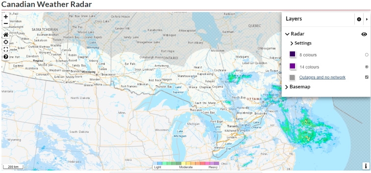 source: weather.gc.ca
Now that we have a real map, could that mean… a real API to weather data that is Open and available to developers? Sure does. Welcome to MSC GeoMet.
MSC GeoMet Online Access
MSC GeoMet has been around for a while now but has stayed under the radar (sorry). So what is MSC GeoMet? A platform that provides public access to the Meteorological Service of Canada (MSC) and Environment and Climate Change Canada (ECCC) data via interoperable web services and application programming interfaces (API). In short, open weather/climate APIs. Precipitation is just one of the hundred or so layers available at this point. Some even mosaic NOAA data for a seamless dataset. Weather needs no passport.
So now that the government radar site is using live Web Mapping Services (WMS), shouldn’t we all start mashing it into our apps?! Maybe we can all stop screen scrapping the GIFs?! Although, when it comes to consistency, those GIF scripts have worked without issue for a decade. Respect.
What’s Next
Hoping the next step for MSC GeoMet is to find a better way to search available data. Leveraging the OpenGov site and combing through the layers in the services is a good start, but hoping for a possible discovery/search tool. This would help more beginners navigate and find some interesting data and lower the bar to adoption. But right now I can’t complain - well done ECCC/MSC, and keep going. There are even a few examples of how to build a simple web map with their data. A few additional examples would be helpful as well, possibly for the layers that are harder to understand - such as Forecasting and modelling data.
I guess the best way to help would be to create some examples as well. I’ll start putting together a follow-up article where we can start leveraging these services with a bunch of web mapping APIs: Leaflet, ArcGIS JavaScript API v3x and v4x, and OpenLayers for good measure.
Helpful Links

If you found my writing entertaining or useful and want to say thanks, you can always buy me a coffee.