Projecting between NAD83 and NAD83 CSRS in ArcGIS


Update 2020-11-04: Fixed a small, yet important, typo in the ‘Create transformation’ steps . Special thanks to Darren M. for catching this.
Update 2018-09-19: Please note that different Geographic systems need specific transformations. As of 2018, CSRS v6 and v7 are becoming very popular - however there is no specific transformations available at this time. If using ArcGIS 10.6x, the newer v6 and v7 Geographic systems are available - in older versions you need to create it. The Guru, Melita Kennedy’s quote: “NAD83 CSRS is a [ongoing] re-adjustment of the original NAD83 geographic coordinate system (datum). Generally, the differences between original NAD83 and the CSRS adjustment are less than a meter, so depending on your data, you may be able to forgo a conversion.” Wise words. So it’s important to think about your requirements, and to document in your metadata how you changed the data. If you are using high quality LiDAR or survey data you need to be careful about setting up the correct transformation (and still update the metadata on how you transformed!).
If you work with data in Canada, be careful when projecting data from one GCS to another (NAD83 and NAD83 CSRS). Why you ask? Even though many Canadian geographic transformations are supported in ArcGIS, the required files aren’t installed by default. Now, before we show up at Jack’s office in Redlands with pitchforks and torches, you should know one thing - it’s not their fault. Matter of fact: Esri, PCI, GeoMedia, QGIS, and other GIS software all have this exact same issue - the grid files are proprietary so the software companies traditionally haven’t been allowed to include them. Blame the pre-Open government era if we must.
I’ve subtly mentioned this before when discussing steps to upgrade ArcGIS. A frequent question I get from that post is “how do I set this up?”, usually followed by “why didn’t anyone tell us?“. To answer the first question, keep reading. As for the latter, hopefully you already knew - and if not, consider this post a rude awaking that your previous NAD83 to NAD83 CSRS transformations didn’t do what you thought (as the tools still “work” without any error messages or warnings). This is the case for many scenarios: Project tool (and raster project tool), ArcMap “on-the-fly” transformations via Data frame properties, and Mosaic dataset geographic transformation options to name a few of the big ones.
Enough background, how do we transform between NAD83 and NAD83 CSRS
Fine, not interested in the background. Let’s get to it then - although I’m still going to start generic. There are two things you should consider when using geographic transformations:
- Is the grid installed: Again, if you are in Canada, the answer is most likely no. Educated guess since the grid folder for Canada doesn’t exist on a fresh install. If someone else installed the software, it’s a good idea to check anyway. Browse to
\pedata\ntv2\canada . If the folder (all small case) doesn’t exist, create it (you will need it eventually). If it already exists, examine the list of NTv2 grid files (*.gsb) inside. If the one you need is there, move to step 2. If it’s not there you can search Google or just contact your Esri distributor as they know where to find the common ones. - Is the NTv2 Geographic transformation already setup/supported. Again, even if supported, if the GSB isn’t located in the directory in step 1 - you need this first. You can see the supported list for more details. If you have the grid file and your transformation and file are listed - congratulations, you are ready to go. However, for those unsupported (Ontario CSRS for example), you will need to create a custom transformation.
Argh, NAD83 and NAD83 CSRS custom transformation already
The supported list of NTv2 Geographic transformations does include a Canada wide transformation (NAD_1983_To_NAD_1983_CSRS_1). This is based on using the NAD83-98.gsb grid file. If this meets your needs, you are good to go - place the file into the “canada” directory, then select the transformation when prompted in the Project tool, ArcMap dataframe settings, etc. If you want to use the Ontario grid file (ON83CSv1.gsb) or Toronto grid file, we are almost there. Verify the grid is in the directory, and we are ready to create our custom transformation.
Update 2018-09-19: Please note that different Geographic systems need specific transformations. As of 2018, CSRS v6 and v7 are becoming very popular - however there is no specific transformations available at this time. If using ArcGIS 10.6x, the newer v6 and v7 Geographic systems are available - in older versions you need to create it. The Guru, Melita Kennedy’s quote: “NAD83 CSRS is a [ongoing] re-adjustment of the original NAD83 geographic coordinate system (datum). Generally, the differences between original NAD83 and the CSRS adjustment are less than a meter, so depending on your data, you may be able to forgo a conversion.” Wise words. So it’s important to think about your requirements, and to document in your metadata how you changed the data. If you are using high quality LiDAR or survey data you need to be careful about setting up the correct transformation (and still update the metadata on how you transformed!).
Create a custom transformation:
- Open ArcToolbox > Data Management Tools > Projections and Transformations > Create Custom Geographic Transformation
- Setup the input and output coordinate systems (this is a bi-directional process so order doesn’t matter)
- Provide a name. No spaces, and you should follow the recommended syntax:
Input_GCS_To_Output_GCS - For Method, select NTv2
- In the parameters section, change the value to match the folder name followed by a forward slash (/) and the GSB file name. The example below uses the Ontario grid file: canada/ON83CSv1.gsb
- Run the tool.
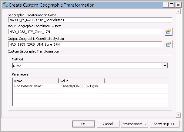 Custom Transformation Tool
Do I need to keep reading?
Nope, that’s it! With the geographic transformation and grid file in place, you can now select it from the transformation from the list. This can be used when projecting data, and even when ArcMap transforms on the fly! You will need to specifically tell ArcMap via the dataframe properties however (yup, on-the-fly projecting in ArcMap wasn’t doing it either). You will also notice that the Projection Tool and ArcMap data refreshing takes longer (since it’s actually doing something now).
Additional Links:
- Any answer on support/geonet by Melita Kennedy. If anything in this post doesn’t align with something Melita said - Melita is correct.
- http://support.esri.com/en/knowledgebase/techarticles/detail/21327
- http://support.esri.com/en/knowledgebase/techarticles/detail/18317
- http://support.esri.com/en/knowledgebase/techarticles/detail/35152
- https://geonet.esri.com/thread/57508
- http://gis.stackexchange.com/questions/127220/proper-transformation-file-to-go-from-nad83-csrs-utm-17-to-nad83-utm-17
- https://www1.toronto.ca/City%20Of%20Toronto/Engineering%20and%20Construction%20Services/Standards%20and%20Specifications/Files/pdf/NAD%2083/nad_83_csrs.pdf

If you found my writing entertaining or useful and want to say thanks, you can always buy me a coffee.